


Location:
Bushman’s Nek Wilderness Area, lower southern Drakensberg. There are two main routes to Tarn Cave, the first being via Bushman’s Nek Pass. After summitting the highest point on the pass, you will encounter a shipping container which might pass as a “border post” except there is no border guard there, just a watchman (sometimes) and a lot of litter. If you follow the jeep track round to the right behind the container, you will soon reach the border fence again, which you should then cross back into South Africa (the fence lies conveniently flat on the ground in places). If you can find your way to the largest tarn, you will pick up the path to Tarn Cave, which will now only be a few hundred metres away.
The more direct route to Tarn Cave is via a ridge which has a very distinct path that you can follow all the way from the split that goes to Lammergeier Cave not far from Cedric’s Pool (Twin Pools). There is a crux on this route just above the Surprise Cave rock art site that involves scrambling up a 2 metre-high rock face, and this may be daunting to some hikers. It is best to pass backpacks up to your most confident group member/s so that everyone else can do the scramble without a weight on their backs. At the top of the ridge you will encounter a large rock formation with a small hole through it. The path to Tarn Cave continues on off to the right, passing a very large, very beautiful tarn before becoming less distinct and perhaps more difficult to follow, but by now you will be less than 250 metres from the cave.
Tarn Cave provides a convenient stop-over for more adventurous hikers wanting to climb the Devil’s Knuckles (also called The Three Bushmen) or traverse the escarpment just below them in the direction of Goat’s Cave and Thaba Ngwangwe. You can also continue on to the new Sehlabathebe Lodge in Lesotho or perhaps even Thomathu village, which both lie behind and to the south of the Knuckles. Unfortunately, the lovely old Sehlabathebe Lodge is closed and going derelict, although you can still camp near the dam, overnight in Irish Cave or even “rent” one of the enclosed cave shelters (mothibos) in the vicinity. Exactly how you go about booking and paying for any of these options may present an insurmountable challenge, however. You should have your passports stamped at the Bushman’s Nek border post if you are going to make an “official” entry into Lesotho by staying at any one of these places, because the Lesotho police do occasionally check on tourists there and the Lesotho army now occupies the staff quarters at the old lodge. The primary purpose of the border post at Bushman’s Nek, though, seems to be to prevent the illegal immigration of Basothos into South Africa, rather than hindering hikers venturing into Lesotho.
GPS Coordinates: WGS 84
S29 51.500 E29 08.255 at 2414 metres (Landlubbers)
Description:
Tarn Cave is a substantial cave with a very good overhang. The lower end contains two main sleeping areas. It can accommodate 12 people with ease, provided some are prepared to forego the comfort of the stone walls that circle the main sleeping areas.
Comfort: 4/5
The sleeping areas are level and smooth.
Water: 3/5
In summer the little waterfall that tumbles over the front of the upper end of the cave can provide all your water requirements, and in winter water may be collected from the tarns above the cave, although this should preferably be filtered and purified if it is to be used for drinking or cooking because it will contain little orange bugs. The tarns can dry up completely in winter though.
Pools: 4/5
There are three large tarns on the plateau above Tarn Cave, two of which are passed en route to the cave. The nearer one (about 150 metres away) is full of weeds and you will definitely have frogs and tadpoles for company in summer. The other tarn (about 250 metres away) is a magnificent one with a gravel floor and some bedrock on which to lie and soak up the sun. In high summer, its outflow forms a small waterfall alongside the path to the cave, ideal for collecting water. The tarns in this area contain a rare species of very tiny, white water flower, so please take care not to damage them. There are several other tarns fairly close by, but if you enjoy a waterfall as a shower, in summer you can traverse off to the right (looking out of the cave) along the base of the rock band, and you will find a nice spot to wash the sweat away.
Shelter: 3/5
This is a dry, relatively sheltered cave in winter, but the wind can roar through it. During a summer storm the substantial drips can turn into a veritable torrent, flooding the top sleeping areas unless they are properly trenched. The cave is very exposed to mist so the lower sleeping areas can get quite damp. The area is very exposed to lightning, and although it can be exciting and spectacular to watch from the shelter of the cave, if it gets too close for comfort, you should probably all take shelter at the very back in the deepest part of the cave. Not so long ago, lightning dislodged a large block of rock at the entrance to the cave. This slid down the hillside some 100 metres before coming to rest, and can still be seen there today.
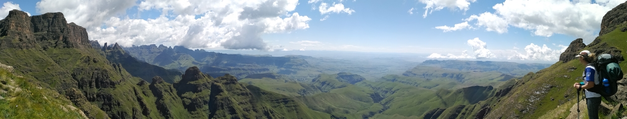
Outlook: 5/5
The cave is north-facing and provides an absolutely spectacular view of the Devil’s Knuckles and the escarpment towards Thomathu Peak. The plateau immediately above the cave is very pretty, especially in summer when it is dotted with flowers. Numerous small rock formations transform the plateau into a fantasy playground.
Overall Rating: 19/25
History:
The cave is named after the tarns on the plateau above it. It must be assumed it was named before Lakes Cave (Cobham Wilderness Area), otherwise Lakes Cave could have been named Tarn Cave because of the tarns which also appear above it!